


The official work for the Bhagalpur Metro Rail project has finally commenced on the ground. Starting February 19, 2026, survey teams have been deployed to various localities including Nathnagar, Aliganj, and Sabour. The task has been assigned to Roadies Survey and Data Services Private Limited, which will conduct a detailed ‘base map survey’ over the next 20 to 25 days. This step is critical for finalizing the route and ensuring that the construction phase faces no technical hurdles.
Which Routes and Stations are Planned?
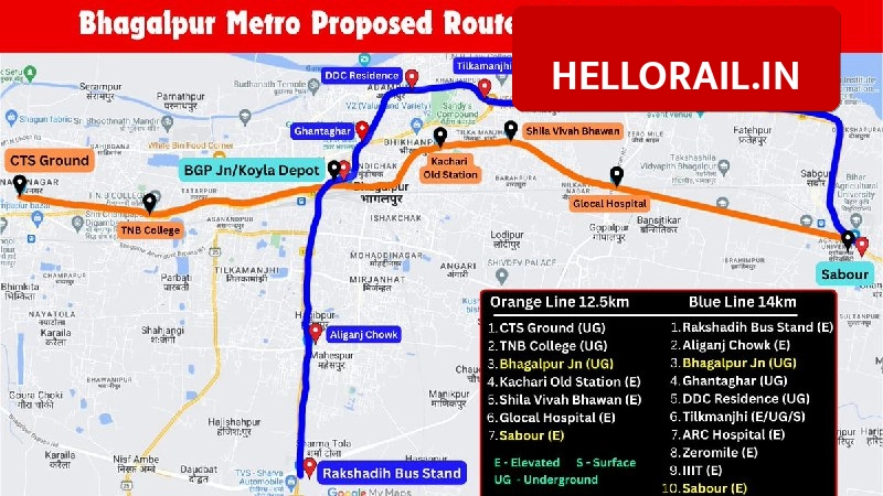
The proposed metro network is designed to ease traffic congestion in the city. The plan includes a total of 22 stations spread across two main corridors. Bhagalpur Junction will serve as the primary interchange station connecting these routes. The officials have identified three specific lines to cover major parts of the city, ensuring connectivity from the outskirts to the city center.
- Corridor 1 (East-West): This route spans approximately 17 km, connecting Champanagar to Sabour.
- Corridor 2 (North-South): This section covers about 12 km, linking Bhagalpur Station to Vastu Vihar.
- Blue Line: Runs from Bhagalpur to Vastu Vihar via Mojahidpur and Maheshpur.
- Green Line: Connects Nathnagar to Tatarpur, passing through Champanagar and TNB College.
- Red Line: Links Bhagalpur Bus Stand to Bihar Agricultural University via Zero Mile.
What is the Purpose of this Survey?
The current survey focuses on creating a high-precision digital base map. Engineers are using aerial imagery and ground tools to record 3D topographical data, such as ground elevation and slopes. A major part of this work involves mapping underground utilities. The teams are identifying the exact locations of electricity cables, water pipelines, and sewage lines. This data is essential to prevent any damage to public utilities when heavy construction begins later.
Additionally, the administration is actively looking for land to establish metro yards. Officials are currently scouting locations in the Jagdishpur and University areas. The Bihar Urban Development and Housing Department (UDHD) is the nodal agency for this project, while RITES Limited is coordinating the technical alignment. The aim is to prioritize government land for these facilities to minimize the displacement of local residents.